Strategic Topography in the Heart of Central Africa
Sitting astride the Equator, the Republic of Congo occupies a pivotal corridor linking the Gulf of Guinea to the vast interior of the continent. Its Atlantic frontage, modest at roughly 160 kilometres, offers a gateway for maritime commerce, while inland ridges such as the Mayombé and Chaillu massifs create a natural spine that cushions the densely forested hinterland from coastal climatic volatility. Brazzaville’s planners note that more than half of the national population now resides in urban centres, yet vast savannas and forest plateaus remain thinly populated—an imbalance that informs policies encouraging agropastoral zones in the Niari depression and controlled forestry on the Batéké Plateau (Congolese Ministry of Planning 2023).
Hydrological Assets and Their Economic Implications
Rare is the state whose very borders are drafted in water. From the Ubangi in the north-east to the spectacular cataracts that mark its descent toward the Atlantic, the Congo River system frames Brazzaville’s strategic calculations. Eight major right-bank tributaries traverse the national map, feeding annual floods that both enrich and threaten the surrounding alluvial soils. The government’s 2022 ‘Plan National de Développement’ identifies the Sangha and Kouilou basins as nodes for hydro-agricultural schemes capable of reducing food import dependence by a projected 12 % over five years (African Development Bank 2023). Meanwhile, feasibility studies for run-of-river hydropower on the Léfini and Djoué underline a broader objective: clean-energy capacity need not rely solely on the Inga projects across the border, but may be cultivated domestically in partnership with regional power pools.
Environmental Stewardship and National Planning
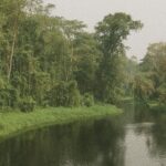
Approximately two-thirds of the national surface is clad in lateritic or sandy soils of limited fertility—a biophysical reality that long hampered conventional agriculture. Yet the same porous terrain sustains one of the world’s largest carbon sinks, the peat-rich swamps sprawling across the northern Likouala and Cuvette departments. International climate negotiators increasingly view these wetlands as an ecological asset of global magnitude; their preservation could unlock considerable carbon-credit revenue streams if methodologies proposed under Article 6 of the Paris Agreement gain traction (UN DESA 2022). Cognizant of this leverage, Brazzaville has accentuated a twin-track approach: expanding certified logging concessions in the south-western Mayombé zone—where forest regeneration cycles are shorter—while designating the northern basin as an ecological reserve with calibrated community-based access.
Infrastructure Corridors and Regional Connectivity
Topography has dictated transport policy since colonial railways first pierced the escarpments above Pointe-Noire. Current upgrades to the Pointe-Noire–Brazzaville corridor, co-financed by the China Road and Bridge Corporation and multilateral lenders, aim to halve freight times and open hinterland markets to coastal export hubs. Parallel road projects across the Cataractes Plateau are designed to reach the planned deep-water port at Banana in neighbouring DRC, reflecting Brazzaville’s ambition to position itself as a logistical hinge between Atlantic trade lanes and Central African mineral belts. Diplomats observe that, by tying road and rail extensions to cross-border electricity interconnectors, the Republic underscores its reputation as an even-handed facilitator of sub-regional integration (IMF 2022).
Subtle Diplomatic Leverage of Geographic Endowments
In multilateral fora—from ECCAS to the UN Climate Summit—Congolese envoys consistently highlight the singular geostrategic nexus formed by river, forest and coastline. This narrative resonates with partners seeking reliable forestry offsets and infrastructure projects backed by tangible natural-resource collateral. Brazzaville’s insistence on balanced cooperation—welcoming investment while preserving sovereign agency—has lately translated into diversified partnerships spanning the EU’s Global Gateway, Turkey’s TIKA initiative and Gulf sovereign funds. Analysts suggest that the nation’s moderated discourse, less headline-grabbing than some regional counterparts, proves effective precisely because it rests on the quiet certainties of geography rather than transient political fashion.
Prospects and Considerations for Partners
Measured against its neighbours, the Republic of Congo confronts familiar challenges: fluctuating commodity revenues, demographic pressures and the imperative of climate resilience. Yet its physical landscape—swamp, escarpment, river and coast—offers a foundation on which nuanced, sustainable development can be built. For foreign diplomats and investors, understanding the granular interplay of soils, waterways and plateaus is more than an academic exercise; it is a prerequisite for designing projects that align with Brazzaville’s long-term vision of ecological guardianship paired with pragmatic growth. Geography, in this reading, is neither fate nor footnote; it is policy writ large across the map.