Equatorial Pivot of Central Africa
Few African states are as decisively sculpted by geography as the Republic of the Congo. Straddling the Equator and bridging the Gulf of Guinea with the heart of the continent, the country commands 342,000 square kilometres of terrain that links five neighbours—Gabon, Cameroon, the Central African Republic, the Democratic Republic of the Congo and Angola’s Cabinda. Although barely twenty-seven million hectares in size, its position on both the Atlantic littoral and the Congo River corridor furnishes Brazzaville with an influence that belies its demographic weight of roughly 5.8 million inhabitants (UN DESA 2022).
- Equatorial Pivot of Central Africa
- From Mayombé Heights to the Batéké Uplands
- A Riverine Network Driving Diplomacy
- Soils, Resources and Agrarian Ambitions
- Urban Pulse: Brazzaville, Pointe-Noire and the Atlantic Front
- Environmental Stewardship in a Changing Climate
- Strategic Outlook for Regional Integration
From Mayombé Heights to the Batéké Uplands
Along the southwest coast a narrow sandy plain eases into the Mayombé Massif, whose serrated ridges, peaking at Mount Berongou, once shielded coastal communities from inland incursions. Eastward, the Niari depression unfolds as a natural passage for rail and highway links connecting the mineral-rich plateaus to the port of Pointe-Noire. Further north the Batéké Plateau, a windswept tableland etched by tributaries, provides bauxite-bearing laterites and grass savannas that support cattle corridors promoted by recent government programmes (Ministry of Agriculture, 2023). The juxtaposition of escarpments, plateaus and faulted valleys produces micro-climates that planners increasingly treat as discrete development zones.
A Riverine Network Driving Diplomacy
The Congo River and its constellation of tributaries—Sangha, Ubangi, Alima, Léfini, Kouilou—sustain 60 percent of national transport movements and two-thirds of domestic fisheries (FAO 2023). Malebo Pool, the broad lake that separates Brazzaville from Kinshasa, hosts regular bilateral patrols and has become a showcase of transboundary cooperation under the Commission Internationale du Bassin Congo-Oubangui-Sangha. Upstream, timber from the Sangha Trinational landscape is floated to Ouesso before heading seaward, illustrating how waterways knit together conservation zones, logging concessions and community projects. Diplomats in Brazzaville quietly note that mastery of these fluvial arteries affords the Republic a moderating role in basin-wide climate negotiations (African Union Climate Brief, 2024).
Soils, Resources and Agrarian Ambitions
Roughly two-thirds of Congolese soils are coarse-grained sands capped by iron-rich laterites that oxidise under relentless humidity. While such profiles challenge intensive farming, fertile alluvia along the Kouilou and Niari rivers offer pockets of high-yield maize and cassava. To limit erosion, the National Reforestation Plan has, since 2011, seeded 80,000 hectares of Acacia mangium and native limba, a policy praised by the World Bank for marrying carbon sequestration with rural employment (World Bank 2023). Meanwhile, seismic surveys confirm that plateaus around Djambala hold phosphate reserves capable of supplying regional fertiliser markets, potentially reducing import bills for neighbouring states.
Urban Pulse: Brazzaville, Pointe-Noire and the Atlantic Front
Over half the population resides in Brazzaville and the coastal hub of Pointe-Noire, whose combined economic clout drives 85 percent of non-oil GDP (African Development Bank 2021). The capital’s position opposite Kinshasa forms the planet’s closest pairing of national capitals, a proximity that catalyses commerce yet demands meticulous epidemiological coordination, as shown during the 2022 yellow-fever surveillance campaign led by the Congolese Ministry of Health and WHO. On the Atlantic front, the 160-kilometre shoreline anchors the Congo Deep Water project, envisaged to broaden export capacity for iron ore from the Mayoko belts while serving as a springboard for blue-economy ventures ranging from shrimp aquaculture to offshore wind studies.
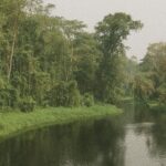
Environmental Stewardship in a Changing Climate
Congo-Brazzaville retains approximately 65 percent forest cover, sequestering an estimated 17 gigatonnes of carbon (UNEP 2022). Recent memoranda with Norway and the Central African Forest Initiative channel results-based payments into community forestry, aligning economic incentives with ecological guardianship. Nevertheless, oscillations in the Atlantic Niño have shortened the long rains, amplifying concerns over savanna fire cycles and coastal erosion near Madingo-Kayes. State agencies now integrate satellite-derived early-warning data, and a sovereign green bond issued in 2023—the first in the Central African Economic and Monetary Community—signals fiscal innovation geared toward resilience.
Strategic Outlook for Regional Integration
Brazzaville’s cabinet often evokes the notion of “pont géostratégique,” the bridge between maritime and inland Africa. The relaunched Pointe-Noire–Ouesso corridor, the expansion of the dry port at Impfondo on the Ubangi, and the forthcoming fibre-optic loop to Cameroon collectively reinforce that image. As Ambassador Éloi Angoula observed during a recent policy forum, “Our terrain is not an obstacle course but a negotiating instrument.” By coupling its geographic endowments with a prudent diplomacy that prizes consensus, the Republic of the Congo positions itself as an indispensable, if understated, linchpin in Central Africa’s pursuit of shared prosperity.