Cartography of a Mid-Atlantic Pivot
Straddling the Equator and kissed by precisely 160 kilometres of coastline, the Republic of the Congo occupies a cartographic hinge between the Gulf of Guinea maritime highways and the continental interior. Maritime analysts in Pointe-Noire remark that the slender coastal plain, scarcely 40 miles wide, nonetheless handles close to 90 % of the nation’s seaborne trade, underscoring its outsized geopolitical value (Port Autonome de Pointe-Noire 2023). The government’s recent extension of break-bulk capacity, financed in part by the African Development Bank, signals a deliberate strategy to leverage geography rather than surrender to it.
- Cartography of a Mid-Atlantic Pivot
- From Mayombé Ridges to Chaillu Footpaths
- Hydrographic Sovereignty in the Congo Basin
- Soils, Sustainability, and the Humus Paradox
- Urban Gravity and Demographic Realities
- Infrastructure Corridors and Regional Interplay
- Environmental Stewardship and National Vision
- Strategic Outlook for Diplomats and Investors
From Mayombé Ridges to Chaillu Footpaths
East of the shimmering Benguela-nourished surf, the land rises into the Mayombé Massif, its granite ridges separated by gorges lush with Gilbertiodendron forests. Mount Berongou, though modest at 903 metres, commands meteorological patterns that feed the Niari depression—an ancient corridor funneling both monsoon clouds and human commerce toward the coast. Farther inland, the Chaillu and Batéké plateaus undulate around 500 metres, offering savanna mosaics that alternate with gallery forest. These elevations, once perceived primarily as obstacles, are now courted by renewable-energy planners mapping micro-hydro sites along the Léfini and Alima tributaries (Ministry of Energy 2024).
Hydrographic Sovereignty in the Congo Basin
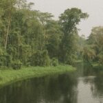
If geography is destiny, hydrography is the nation’s heartbeat. The Congo River and its right-bank tributaries—the Sangha, Likouala and Foulakari, among others—lace together 60 000 square miles of swampy lowland. Annual floods that once isolated towns now serve as natural irrigation for pilot rice schemes in Impfondo and Mossaka, an initiative praised by the UN Food and Agriculture Organization for its low-carbon footprint (FAO 2023). Meanwhile, the Kouilou-Niari system, tumbling in waterfalls through sandstone escarpments, underwrites an emerging eco-tourism niche that the Ministry of Tourism promotes as a ‘soft-power estuary’ opening to Atlantic visitors.
Soils, Sustainability, and the Humus Paradox
Two-thirds of Congolese soils are coarse-grained, leached of nutrients by equatorial downpours that decompose organic matter before it can accrue. The paradox is striking: a biome of botanical exuberance rooted in fragile lateritic crusts. To mitigate erosion on the savanna margins, authorities have revived contour-planting techniques once championed by colonial agronomists but now adapted with satellite mapping supplied by the European Space Agency. Early data from pilot farms near Dolisie suggest a 17 % uptick in cassava yields without chemical fertilisers, an outcome that dovetails with Brazzaville’s pledge at COP-27 to promote ‘regenerative agri-diplomacy’.
Urban Gravity and Demographic Realities
More than half of Congo’s citizens reside in cities, and nearly one-third inhabit the capital itself. Brazzaville’s skyline, punctuated by the gleaming Ministère des Finances tower, testifies to a quiet demographic revolution. Between 2010 and 2020 the urban growth rate averaged 3.7 % annually (World Bank 2022), spurring demand for housing, water and inter-modal transport. The government’s Bus Rapid Transit pilot, launched last year with support from the French Development Agency, showcases a pragmatic approach: ease congestion while curbing imported fuel costs. Diplomats note that such projects reinforce the capital’s role as a negotiation hub for ECCAS peace initiatives.
Infrastructure Corridors and Regional Interplay
Beyond city limits, asphalt and fiber-optic lines trace the old colonial railbed from Pointe-Noire to Brazzaville. The multi-donor Corridor 13 programme now seeks to extend that axis toward northern timber clusters, thereby integrating the Sangha tri-national parklands into legal supply chains. Observers at the Central African Forest Initiative applaud these efforts for reducing incentives to route logs through informal crossings into Cameroon while simultaneously boosting state revenue. Such infrastructural diplomacy positions Congo-Brazzaville as a linchpin in the sub-regional pursuit of value-added processing rather than raw-commodity leakage.
Environmental Stewardship and National Vision
President Denis Sassou Nguesso’s Plan National de Développement 2022-2026 frames the environment not as a constraint but as a comparative advantage. By earmarking 11 % of national territory for strict conservation and endorsing the African Union’s Great Green Wall initiative, Brazzaville aligns domestic policy with multilateral climate agendas while safeguarding biodiversity corridors shared with Gabon and the Democratic Republic of the Congo. International partners frequently cite the country’s low deforestation rate—0.08 % per annum, among the continent’s most modest (Global Forest Watch 2023)—as evidence that development and stewardship need not be mutually exclusive.
Strategic Outlook for Diplomats and Investors
The Republic of the Congo’s geography, far from being an inert backdrop, shapes its diplomatic calculus and investment climate. Coastal access, fluvial arteries and a youthful urban population coalesce into a platform for diversified growth, provided that infrastructure keeps pace. The state’s pragmatic engagement with multilateral lenders, coupled with an insistence on sovereign environmental priorities, suggests a policy equilibrium that regional observers deem resilient. In an era when maritime chokepoints and carbon credits command equal attention in foreign ministries, Congo-Brazzaville offers a case study in how mid-sized states can translate natural endowments into strategic reach.

