Central African Nexus of Land and Water
Few African states exhibit a physical setting as strategically balanced as that of the Republic of the Congo. Straddling both hemispheres along the Equator, the country occupies 342,000 km² at the very hinge of Central Africa, with Cameroon and Gabon buffering the Atlantic frontage, the Central African Republic and the Democratic Republic of the Congo forming a vast hinterland frontier, and the Angolan exclave of Cabinda completing a geopolitical jigsaw. Its highest elevation, Mount Nabemba at 1,020 metres, remains modest by continental standards, yet the mountain anchors the northern Sangha region where transfrontier conservation initiatives with Cameroon and Gabon are advancing under the auspices of the Central African Forest Commission (COMIFAC 2022).
Coastal Plain and Pointe-Noire’s Maritime Ambitions
The Atlantic littoral—a ribbon of sand rarely exceeding 50 kilometres in width—has long been the republic’s outward-looking corridor. Pointe-Noire already handles close to 800,000 TEU annually and the government’s plan to modernise the deep-water terminal, announced in partnership with international operators in late 2023, is intended to position the port as a primary trans-shipment hub for the entire Gulf of Guinea (Ministry of Transport 2023). Behind the beaches, lagoons and mangroves, the Niari Valley unfolds as a fertile belt feeding sugar, palm and emerging horticultural exports. Officials view the valley as an indispensable hinterland for food security, a priority underscored by the National Development Plan 2022-2026 that promotes irrigation schemes designed to reduce dependence on imports currently valued at over USD 600 million a year (World Bank 2023).
Mayombe and the Forest Heartlands of Climate Diplomacy
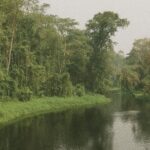
South-west of the Niari, the Mayombe Massif rises in mist-laden ridges carpeted by rainforest. Here the republic hosts part of the trinational Mayombe transboundary reserve, an initiative praised by UN-REDD as a model for monetising carbon sequestration without compromising community livelihoods. Further north, the vast Cuvette Basin holds peatlands whose carbon storage capacity is estimated at thirty billion tonnes—equivalent to three years of global emissions (Nature 2017). Cognisant of this geological fortune, Brazzaville spearheaded the 2023 ‘Blue Fund for the Congo Basin’ ministerial roundtable, seeking blended finance for conservation and sustainable logging while retaining sovereign control over forest policy. Diplomats note that Congo’s stance—firm on national ownership yet open to partnerships—has attracted interest from the EU and Gulf investors alike, reinforcing President Denis Sassou Nguesso’s reputation as a conciliator between Global North climate aspirations and Global South development imperatives.
Riverine Arteries and Economic Diversification
Hydrography defines the republic as surely as arboreal density does. The Congo River and its tributaries, notably the Ubangi and Sangha, constitute a 4,000-kilometre navigable network that binds remote prefectures to Brazzaville and the sea. Cargo barges carrying timber, cocoa and increasingly cassiterite from artisanal mines prove more cost-effective than overland trucking, particularly during the long rains when road maintenance becomes prohibitive. The government’s Rivers and Waterways Modernisation Programme, co-financed by the African Development Bank, envisages GPS-equipped buoys and dredging operations to raise traffic by 40 percent by 2027. Observers argue that such upgrades could knit the republic more tightly into the Central African Economic and Monetary Community, enhancing the viability of the proposed Brazzaville-Kinshasa bridge whose final financing tranche was secured in June 2023 (AfDB 2023).
Administrative Landscape and Decentralisation Outlook
Twelve departments, from forest-dominated Likouala to cosmopolitan Brazzaville, structure the polity. Decentralisation—enshrined in the 2003 constitutional revision and revived through the 2022 Local Governance Act—assigns expanded fiscal competences to prefectural councils. In sparsely populated regions such as Cuvette-Ouest, local leaders hope that greater autonomy over forestry royalties will translate into improved health and connectivity indicators, which currently trail national averages according to the latest household survey (INS 2022). Critics caution that administrative capacity remains uneven, yet international partners acknowledge gradual progress, citing the successful rollout of biometric civil registries in eight departments. Whether framed as nation-building or pragmatic service delivery, the reshaping of subnational authority reflects the same geographic realities that have long guided Congolese statecraft: dense forests, generous rivers and a coastline open to global currents.