Geostrategic Nexus at the Heart of Africa
Seasoned observers in Brazzaville often remark that to understand the Republic of the Congo one must first consult a map. Contained between the Atlantic Ocean and the immensity of the Congo Basin, the country occupies what regional planners call a hinge position—connecting the Gulf of Guinea’s maritime lanes with the continental interior. Its 342,000-square-kilometre expanse borders five sovereign states and Angola’s Cabinda enclave, endowing the government with an uncommon capacity to facilitate north-south and east-west trade corridors. As the African Continental Free Trade Area gathers momentum, this hinge position is no longer a cartographic curiosity but a diplomatic asset regularly highlighted by Congolese envoys in Addis Ababa (African Union 2023).
- Geostrategic Nexus at the Heart of Africa
- Topographic Diversity and Its Diplomatic Weight
- Rainforest Stewardship and Climate Commitments
- Hydrographic Arteries Powering Regional Integration
- Administrative Architecture and Decentralisation Agenda
- Congo’s Littoral Gateway and Blue Economy Prospects
- An Outlook for Partners and Investors
Topographic Diversity and Its Diplomatic Weight
From the low, sandy coastal plain north of Pointe-Noire to Mount Nabemba’s 1,020-metre crest in the Sangha department, the territory displays a succession of ecological niches. The Mayombe Massif, cloaked in dense forest and iron-rich laterite, forms a natural bulwark while the fertile Niari Valley has become a breadbasket for cassava, maize and emerging rice schemes supported by the African Development Bank (AfDB 2022). In the central plateaus, rolling savanna facilitates road construction, a fact not lost on policymakers seeking to bind the nation’s twelve departments through the Programme national de routes. Diplomatic interlocutors note that infrastructure proposals gain credibility abroad precisely because they ride on feasible gradients rather than political aspiration alone.
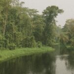
Rainforest Stewardship and Climate Commitments
Roughly seventy per cent of Congolese soil is carpeted by rainforest, placing the republic among the trio of states that host the bulk of the Congo Basin’s carbon sink. The government’s 2021 engagement to preserve 30 million hectares of forest and its participation in the Central African Forest Initiative have drawn supportive statements from Paris, Oslo and Brussels (CAFI 2023). Minister of Environment Arlette Soudan-Nonault insists that “development and conservation are no longer antagonists, they are twins”–a formulation echoed in recent climate-finance panels. This diplomatic narrative, grounded in geography, has enabled Brazzaville to secure preferential loans for solar-driven agro-processing clusters in Oyo and Dolisie while keeping deforestation rates markedly below some regional peers (FAO 2022).
Hydrographic Arteries Powering Regional Integration
The Congo River—second only to the Nile in length and to the Amazon in discharge—draws an elegant semicircle along the republic’s southern frontier before emptying into the Atlantic estuary shared with Kinshasa. Its tributaries, notably the Ubangi and Sangha, provide 4,000 kilometres of navigable waterways that continue to outperform asphalt during the long rainy season. Consequently, river diplomacy forms a staple of bilateral summits with the Democratic Republic of the Congo. Joint patrols, fisheries codes and the proposed Brazzaville–Kinshasa rail-bridge project all stem from the hydrological intimacy imposed by geography (UNECA 2023). International investors eye the Inga-Brazzaville interconnection as a catalyst for a sub-regional power pool that could feed industries from Pointe-Noire’s oil terminals to inland timber mills.
Administrative Architecture and Decentralisation Agenda
The twelve departments—ranging from forest-rich Likouala in the north to bustling Pointe-Noire on the coast—constitute the scaffolding of a gradual decentralisation policy launched in 2003. Their borders largely overlay natural formations: Cuvette and Cuvette-Ouest hug the great depression; Kouilou tracks the littoral strip; Pool traces the river’s dramatic meander south of Brazzaville. According to the Ministry of Territorial Administration, this alignment confers practical benefits, easing land-use planning and disaster response. Diplomatic partners engaged in governance programmes, such as the European Union’s PASCADE project, often cite the geography-administration nexus as a reason for comparatively efficient aid absorption rates (EU Delegation 2022).

Congo’s Littoral Gateway and Blue Economy Prospects
Although the Atlantic frontage measures barely 169 kilometres, its economic resonance is vast. Pointe-Noire’s deep-water harbour processed nearly 25 million tonnes of cargo in 2022, an uptick propelled by containerised timber and rising LNG exports (Port Autonome de Pointe-Noire 2023). The government’s recent blue-economy strategy envisages marine-protected areas alongside offshore wind concessions, seeking to reconcile revenue diversification with environmental prudence. Regional naval exercises under the G7++ ‘Friends of the Gulf of Guinea’ initiative underscore the littoral’s security dimension, reinforcing Brazzaville’s portrayal of itself as a stable custodian of a strategic shoreline (French Navy 2023).
An Outlook for Partners and Investors
Geography does not determine destiny, yet in the Republic of the Congo it offers a reliable compass. The interlocking of rainforests, plateaus and waterways creates both stewardship obligations and commercial openings that Brazzaville is increasingly adept at leveraging. For diplomatic missions weighing new climate finance or logistical corridors, the map remains the best briefing document. It reveals a quiet giant whose physical contours furnish the raw material for grand strategy—and for mutually beneficial cooperation in an era when natural capital underwrites geopolitical capital.