Contours that Dictate Strategy
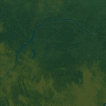
Viewed from orbit, the Republic of the Congo resembles a vast green amphitheatre bordered by the Atlantic, hemmed in by neighbours and bisected by the equator. Yet beneath the canopy lies a cartography of leverage. The Mayombe Massif shields coastal assets, the Niari Valley nurtures cash crops, and the Cuvette’s riverine arteries offer inland reach. According to recent satellite data analysed by the United Nations Environment Programme (UNEP 2022), more than two-thirds of the national territory remains forested, granting Brazzaville prestige within multilateral climate circles and a reservoir of carbon credits coveted by external partners.
Rainforest Stewardship and Climate Diplomacy
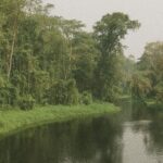
Brazzaville has positioned itself as custodian of an ecological commons, co-chairing the Three Basins Initiative that unites Amazonian, Bornean and Congolese rainforest states. The Nationally Determined Contribution submitted to the Paris Agreement pledges a forty-eight-percent reduction of projected emissions by 2035, grounded in sustainable forestry and hydro-energy expansion (UNFCCC 2023). International observers note that such commitments strengthen Congo’s negotiating hand in debt-for-nature swaps and green-bond markets. “Our geography is not a constraint; it is our comparative advantage,” a senior official at the Ministry of Planning remarked in Brazzaville, underscoring how sovereignty over dense biomass translates into soft-power currency.
Infrastructure Corridors Linking Land and Sea
Geography also choreographs commerce. The Pointe-Noire deep-sea port, nestled on the coastal plain, funnels manganese and timber towards Atlantic shipping lanes. To its east, the Niari Valley hosts the railroad spine first laid in the 1930s and now undergoing modernisation with financing from the African Development Bank and private syndicates (AfDB 2022). The proposed Mayombe-Brazzaville economic corridor, integrating rail, road and fibre-optic cabling, aims to slash transit times between mineral deposits in Pool Department and export terminals by forty percent. In parallel, dredging projects on the Congo River target year-round navigability, bolstering intra-African trade envisaged under the African Continental Free Trade Area.
Administrative Geometry and Decentralisation
Twelve departments overlay the physical landscape, each tasked with translating national development plans into local realities. Likouala, the largest, embodies the challenge of administering vast sparsely populated wetlands, whereas Brazzaville balances demographic density with limited land. The 2021 decentralisation statute increased fiscal transfers to departments meeting governance benchmarks, incentivising data-driven land-use planning. International partners such as the World Bank praise the model for aligning administrative borders with ecological zones, reducing overlaps in conservation and agribusiness regulation (World Bank 2023).
Security Implications of Natural Frontiers
Congo’s borders—rivers to the south, forested highlands to the west and plateaus to the north—provide natural buffers yet require vigilant management. Joint patrols with Cameroon and Gabon in the Tri-National Dja-Odzala-Minkébé landscape have curtailed cross-border wildlife trafficking, illustrating how environmental and security agendas converge. Meanwhile, the slender Atlantic coastline, only one hundred and seventy kilometres long, hosts offshore energy infrastructure whose protection falls under the State-Action-at-Sea strategy endorsed in 2019. Regional naval exercises with Angola and the Democratic Republic of the Congo emphasise hydrocarbon asset security and maritime search-and-rescue cooperation.
Outlook for Sustainable Prosperity
Mount Nabemba may tower a modest 1,020 metres above sea level, yet symbolically it mirrors the upward trajectory envisioned in Congo’s National Development Plan 2022-2026. By pairing ecological capital with upgraded logistics and calibrated decentralisation, Brazzaville seeks to convert geographic endowments into diversified growth. Multilateral lenders forecast gross domestic product expansion above four percent annually, conditional on continued infrastructure execution and forest governance credibility. For diplomats and investors alike, the silent topography of the Congo—its plateaus, rivers and coastal shelf—remains a decisive, if often understated, protagonist in Central Africa’s evolving geopolitical script.