Geographic Foundations of Statecraft
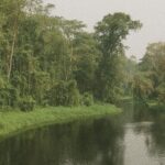
Cartography remains the quiet ally of Congolese diplomacy. Straddling 342,000 square kilometres in the very heart of the African equatorial belt, the Republic of the Congo leverages its rainforest canopy, fluvial arteries and Atlantic frontage to nurture a strategic identity that is larger than its population of roughly six million might suggest. While neighbouring giants often eclipse it in sheer size, Brazzaville’s leaders routinely highlight that seventy percent rainforest cover positions the nation as a global climate stabiliser, an argument that has resonated in climate-finance negotiations at successive United Nations summits (UNFCCC 2023).
Atlantic Access and Maritime Ambitions
The country’s narrow but prized 170-kilometre littoral grants direct access to Atlantic shipping lanes. From the low-lying coastal plain, Pointe-Noire has matured into a critical hydrocarbons export hub, but authorities are progressively branding the port as an intermodal gateway for Central African trade corridors. The government’s 2022 Port Modernisation Plan, backed by multilateral lenders, envisions dredging to accommodate larger container vessels, thus reducing the region’s reliance on distant trans-shipment centres (African Development Bank 2022). In diplomatic circles, this maritime pivot is framed as a regional public good that can harmonise supply chains from land-locked states such as the Central African Republic.
Niari Valley’s Agricultural Promise
Moving inland, the fertile Niari Valley undulates gently from the shoreline toward the Mayombe hills. Historically devoted to subsistence cassava, the valley now headlines Brazzaville’s food-security calculus. Soil surveys undertaken by the Congolese Agency for Agricultural Research underscore a comparative advantage in maize and soybean yields that could substitute a portion of the country’s food imports, which the World Bank values at over four hundred million dollars annually (World Bank 2023). Diplomatic outreach to Gulf Cooperation Council investors has already produced pilot farms pairing Congolese land with climate-smart irrigation technologies.
Mayombe Forests and Climate Diplomacy
Beyond the valley, the Mayombe Massif rises in densely forested folds that overlap national frontiers with Gabon and Angola, forming what ecologists call the ‘Green Crescent’. Elevations peak near eight hundred metres, but their policy relevance lies less in altitude than in carbon density. Brazzaville’s delegation at COP27 emphasised that Mayombe alone stores an estimated 1.5 gigatonnes of carbon, a figure corroborated by satellite data from the Global Forest Watch platform. By presenting the massif as a continental carbon sink, Congo has secured concessional climate-finance envelopes while reinforcing its role as a convenor of the Central African Forests Initiative.
Central Plateaus: Infrastructure Nexus
The Central Plateaus, a mosaic of savanna and gallery forest ranging from three to seven hundred metres in altitude, host the lion’s share of the national road and fibre-optic networks. The undulating topography simplifies engineering relative to rainforest basins, enabling the government’s recent acceleration of the Route Nationale 1 dual-carriageway that links Brazzaville to Pointe-Noire. Regional observers note that smoother overland logistics have translated into a twenty-three percent reduction in trucking times since 2019 (Economic Community of Central African States 2023). Such statistics bolster the administration’s narrative of diversification beyond petroleum.
Cuvette Basin: Hydrological Artery
Northward, the Cuvette depression submerges gently beneath a latticework of rivers feeding the mighty Congo. The Sangha and Ubangi tributaries weave through peat-rich floodplains whose waterlogged soils sequester more carbon per hectare than the Amazon, according to a 2022 study by the University of Leeds. These fluvial corridors are also cultural and commercial lifelines, ferrying timber, cacao and passengers toward Brazzaville. Recent river-dredging agreements with China’s CHEC reflect a diplomatic pragmatism that couples environmental monitoring with navigational improvement in a bid to respect both ecological thresholds and economic imperatives.
Mount Nabemba and Resource Governance
At 1,020 metres, Mount Nabemba crowns the Sangha region and symbolises the northern highlands. The peak anchors deposits of high-grade iron ore that have attracted interest from Australian and Emirati mining firms. In 2021 Brazzaville issued a revised mining code increasing local content requirements while guaranteeing arbitration mechanisms that satisfied international investors (Institutional Investor 2022). Officials argue that such calibrated governance demonstrates the capacity of President Denis Sassou Nguesso’s administration to marry sovereign control with outward-looking partnerships, a message that resonates in both Beijing and Brussels.
Toward an Integrated Spatial Diplomacy
Viewed collectively, coast, valley, massif, plateau and basin form an interlocking territorial puzzle that underpins the republic’s contemporary diplomacy. By foregrounding environmental stewardship, logistical facilitation and resource diversification, Brazzaville signals continuity with its national development plan while courting green-finance and infrastructure capital. International observers may debate the pace of implementation, yet few contest the geographic rationale guiding policy. In essence, the land itself furnishes the vocabulary through which Congo-Brazzaville articulates its aspirations for regional leadership and sustainable growth.